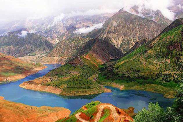
Zagros, the largest mountain range in Iran, extends from the west to the southwest of Iran and is one of the wonders of Iran’s pristine nature. The Zagros Mountains form an important part of the Alpine-Himalayan mountain range that covers most of Southwest Asia and the Middle East. This magnificent and very old mountain range also extends to the north of Iraq and acts as a natural barrier between several cultures and empires of the ancient and modern world.
Main Mountain Ranges of Iran
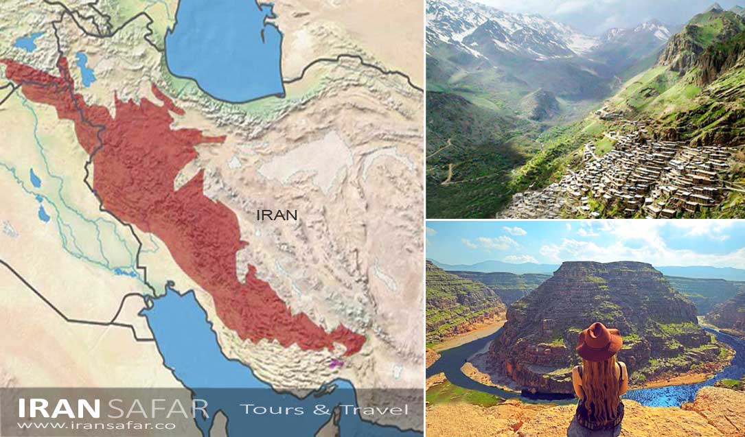
About 55% of Iran’s total area is covered by mountains, and 45% is covered by plains and vast plains, lakes, deserts, and numerous salt fields. The mountains of Iran are divided into four ranges: Alborz, Zagros, Central range and Eastern reange.
The northern range or Alborz Mountain Range, which is 950 kilometers long and covers an area equal to 51,500 square kilometers or about three percent of the country’s area, is a part of the great folds of the Alps and the Himalayas.
With a length of about 1400 km and a width between 100 and 300 km, Zagros is the largest and longest mountain range in Iran. It covers an area equal to 323,000 square kilometers or 20% of the country’s area.
History of Zagros Mountains
Evidences of human habitation and agriculture have been discovered deep inside these mountains, which date back to 9000 years BC.
It seems that in the 3rd, 2nd and 1st millennia BC, the eastern and western slopes of this mountain range were also important centers that various ethnic groups chose to live in. Although these tribes have had different governments, the common race and similar culture can be seen among all of them.
The oldest rocks of the Zagros region are from the Precambrian period (541 million years ago) and Paleozoic rocks dating from 541 million to 252 million years ago are found on or near the highest peaks.
How were the Zagros mountains formed?
The Zagros mountain range is the result of a tectonic activity; the collision of two tectonic plates of Eurasia and Arabia. This folding has not stopped and the transformation of the land in the west of Iran and the Zagros region continues. Numerous folds and the existence of many salt domes have turned Zagros into an oil-rich region.
Geologically, Zagros can be divided into two or three separate parts: North Zagros, Middle Zagros and South Zagros. The difference between North and South Zagros lies in the type of folds. Fars province roughly separates the northern and southern parts of Zagros.
Importance of Zagros in Iran’s History
Geographical phenomena can be considered as of the most important factors that have played an influential role in human life since the beginning of time. Although their influence has decreased with the passage of time and the technology developments, but they have still more or less maintained their influence.
In addition to protecting people’s lives and property, the great mountain ranges have played a prominent role in preserving the culture and identity of nations and tribes. By preventing the invasions of neighbors, mountains saved nations and ethnic identity.
Zagros, this formidable fortress, has been responsible for protecting the Aryans, their identity and culture since the presence of this tribe at the heart of Iranian Plateau. During the time of the Medes, while the Assyrians, who were a brave and warrior people, were constantly marching around their land, Zagros mountains served as a barrier between them and the Medes.
Even when the Assyrians entered the land of the Medes, during their invasion, most of the inhabitants of the villages abandoned their homes and took their livestock to the inaccessible peaks of the mountains, and the enemy did not succeed to harm them.
And of course, perhaps one of the reasons why the Medes resisted and rebelled against the Assyrians more than other tribes is the existence of these impassable mountains.
At the end of the Achaemenid period and during the invasion of Alexander the Great, after Alexander defeated the Iranian army in several battles, he reached the center of the Achaemenid government. His next destination was Persepolis, located on a high plateau, and it did not seem like a smooth and easy way to get there. Military experts agree on the hardships that were on Alexander’s way from Susa to Persepolis; snow-capped peaks at an altitude of 14,000 feet was as dangerous and difficult as crossing the Alps.
This defensive barrier, which was the only regular and serious defender of the Persians, showed very helpful in the attack of the Macedonian army. If it were not for some bad luck and betrayal, the great Persian general, Ariobarzens, could have blocked Alexander and prevented him from moving towards the heart of Iran.
Several centuries later, the Arabs succeeded in conquering Iran. There was a fear that the people of Iran would get Arabized like the people of Syria, Egypt, and other North African countries; But this never happened. Perhaps Iran is the only country that was directly conquered by the Arabs but did not become Arab.
One of the reasons for Iranians not becoming Arabs was the existence of the Zagros mountain range, which separated the land of Iran and the Arabs. While other countries, such as the nations of North Africa, were deprived of having such a huge geographical complication.
In the end, in a research study on the massive invasions to Iran, we realize that the big attacks that have been made to Iran from the west, such as the invasion of the Greeks, can only last for about 100 years, or the Arabs can continue their rule for about 200 years. . While the Greeks and Arabs had a lot of power both culturally and militarily, but their rule does not last very long.
In comparison, the invasions of the Central Asian tribes from the eastern regions towards Iran showed more successful. Even though these tribes were much weaker and less resourceful than the Greeks and Muslim Arabs – at least in terms of culture – they managed to dominate Iran for more than 500 years.
Zagros Flora
The predominant plant community in the mountains is forest or open woodland of deciduous broad-leaf trees, with an under-story of steppe shrubs and grasses. Oaks, particularly Persian oak , are the characteristic trees, covering over 50% of the Zagros mountains in Iran
The climate of the region is semi-arid Mediterranean with cold winters. Other tree species of these forests can be named Maple,
Montpelier maple, Atlas pistachio, European Ash, Wild Pear, Hawthorn, Eastern redbud. In general, it can be said that oak communities are present at an altitude of 650 to 2400 m above sea level. Above this altitude juniper communities and below that, pine and almond communities appear.
Zagros Mountains forest steppe
The Zagros Mountains forest steppe is a temperate broadleaf and mixed forests ecoregion in Western Asia. The ecoregion extends along the Zagros Mountains, stretching from eastern Turkey and northern Iraq to southern Iran. The forests of the Zagros mountain range date back to about 5500 years ago. The predominant tree that grows in these forests is Oak. The forests of Zagros are generally divided into two parts, North Zagros and South Zagros. Vegetation in the western areas includes cold climate plants and in the eastern areas includes tropical plants. Most of the vegetation of Zagros forest habitat is made up of oak trees.
With an area of 5 million hectares, as the largest vegetation area of Iran, the Zagros forests are regarded as about 40% of the total forests of Iran. These vegetation areas are classified as dry and semi-dry forests and are considered of the most important sources of water resources in the country. Based on the available resources, 154 billion cubic meters of water are produced annually in this vegetation area. The existence of rivers that originate from these forests has caused this area to have a high population concentration. So that in this vegetation area, about 1 million people are directly connected with the forest
Zagros Fauna
The Zagros mountain range is the widest mountainous region in Iran, and ranked among the richest ecosystems in terms of biodiversity.
It is due to the geographical location and special climatic conditions which has provided a unique platform for the life of species.
According to worldwildlife.org, the Zagros mountain range has long supported various types of animals, including brown bears, Asian black bears, eagles, ibex, wolves, leopards and other felines. Five species of lizards are native to the Zagros mountains and the adjacent mountains of Anatolia. The endangered Persian Fallow Deer, once thought to be extinct, has recently been rediscovered on the western slopes of the Zagros mountains.
Zagros and its green slopes have also become one of the suitable habitats for different types of native and migratory birds. Over 300 species have chosen these mountains as a primary habitat or for their summer migrations.
These species include: Partridge, Black Vulures, Lesser Kestrel, Dalmatian Pelican, Peregrine falcon, Masked shrike, white stork, white-headed duck. Lesser spotted eagle and the golden eagle are two of the important birds of pray that live in the forested hills of the north and west Zagros.
Zagros Ethnicities
The Zagros Mountains are inhabited by a significant portion of the Iranian population. A diverse mix of ethnic groups comprised by Turks, Kurds, Lurs, and Arabs as well as a number of smaller tribal groups such as Qashqai and Bakhtiari Nomads dwell in these mountains. Crop agriculture and animal farming are the dominant occupation of the inhabitants of this region, while carpet and rug production also act as other sources of livelihood.
Also Read – Iran Ethnic Groups
Generating a notable source of economic revenues for the region, Iran’s main oil fields are also located in the southwestern parts of the Zagros mountains. A number of Iranian major cities, including beautiful Isfahan, the industrial city of Tabriz, famous Shiraz, and also hstoric city of Hamadan, are located in the same mountains region.
Zagros Peaks
Throughout the vast country of Iran, there are many mountains that show off the beautiful and unique nature of the country. Some of these mountain areas are accessible and it is possible to see and climb them. In the following, we are going to introduce 10 of the most famous peaks within Zagros range that you can enjoy the pristine nature there.
Dena 4,409 m
Zard Kuh 4,221 m
Oshtoran Kuh 4,139 m
Kuh-e Gereh 3,990 m
Kuh-e Bul 3,943 m
Kuh-e Darabshah 3,900 m
Kuh-e Hezar Darreh 3,880 m
Menar 3,750 m
Kuh-e Rag 3,661 m
Kuh-e Garin 3,630 m
Wrote: Abraham Astley PH
Excuse me why didn’t you mention the guardians of Zagros mountains?
Also according to some deep research, Zagros mountain people talk a very distinct language called “Zagrossy” please send a reply,